Asgartha

Lore
February 26th, 2024
Reading time
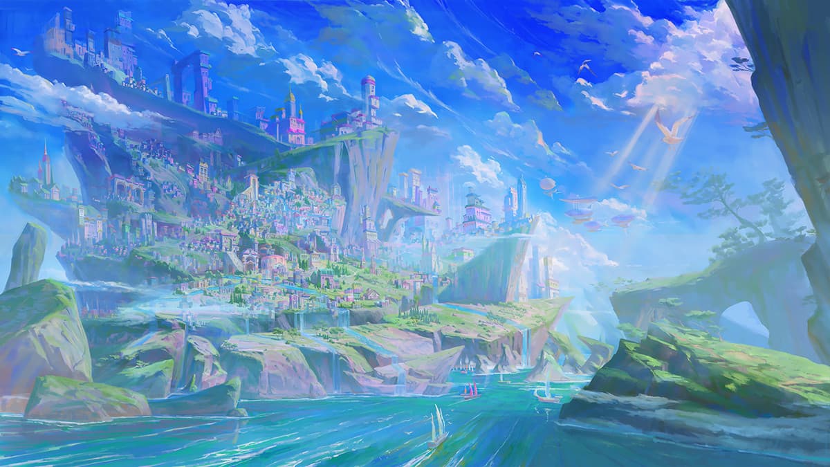
The Asgarthan Peninsula is considered the new epicenter and cradle of human civilization. Despite its rather modest size and complete isolation, this fragmented strip of land has become a biotope where sentient beings have managed to thrive, despite the limited natural resources presented by this ecosystem. In the absence of evidence of the existence of other enclaves, Asgartha is considered the last bastion of humanity.

Capital : Arkaster
Demographics
Demonym : Asgarthan Population :
- Total : approx. 2,787,000 inhabitants
- Arkaster : approx. 695,000 inhabitants
Government : Deliberative republic
Monarch : Basileus Avkan ruun-Heshkari
Language : Asgarthan
Area : approx. 42,600 km² (16,448 sq mi)
Currency : Asgarthan Floret
Calendar : Asgarthan (Era : AC for “Anno Concordiae”)
The majority of Asgartha falls under the jurisdiction of the city of Arkaster. The entirety of the administered territories is referred to as the Asgarthan Protectorate. The Protectorate is divided into several autonomous Provinces, known as Caers. There are 5 Caers: Caer Eidos, Caer Kettria, Caer Arcolano, Caer Esvander, and Caer Alcada. While the territories of Vagheria and Suspira are directly under the control of Arkaster, the Kirighai peninsula (which includes the Katkera and the Silg) is recognized as a neutral and independent zone.
Throughout its history, the borders of Asgartha have continuously shifted. Initially centered around the city of Arkaster, the Protectorate incorporated more and more regions as the Peninsula was explored. However, this otherwise continuous expansion was disrupted on one occasion several centuries ago. Beyond the Rampart, a sixth Province was once attached to Asgartha before it was seized from the Protectorate.
Geography
The Peninsula known as Asgartha covers a total area of approximately 16,448 sq mi (42,600 km²), spanning a distance of about 516 mi (830 km) from east to west. The Asgarthan Peninsula features four smaller peninsulas - Anthea, Kirighai, Enosha, and Vagheria - along with three minor peninsulas making up the isthmus of Caer Eidos, the only strip of land connected to the mainland. All these peninsulas are surrounded by sandy shallows, which are easy to cross, even on foot during the Season of Mists, when the water evaporates to become a persistent fog.
The Peninsula also hosts an island called Suspira, located at its eastern end. The Enosha peninsula exhibits a striking feature. Attached to the ground at its western part, it gradually stretches skyward to become an island suspended in the air. The highest point of the peninsula is called the Auriga, which culminates at 16,000 ft (4,879 m). This peak takes root in the Enosha region known as the Makonis Heights, located in the eastern part of the island.
The Peninsula is surrounded by several seas: the tempestuous and perilous Cierna to the north, and the calmer and more fish-abundant Biela to the south. It also includes a sea located beneath the floating Enosha peninsula, called the Undersea. The rest of the maritime expanses consist of shallows: the Muir Concordia lagoon forms an inland sea, while the Shawl is a shallow strip of sea connecting the peninsulas of Anthea, Kirighai, and Enosha.
The scarcity of pre-cataclysm references complicates the localization of Asgartha on the few surviving maps. Worse still, Ordis scholars believe that the geology of the Peninsula has been heavily influenced by the Tumult, and that the area, along with its climate, has likely been drastically altered from what it was before the Confluence. However, there are indications regarding Asgartha's positioning in relation to the Ancient World.
Climate
The Asgarthan Peninsula experiences a wide variety of climates. However, these climates no longer seem to be generated only by meteorological phenomena, but rather by the concepts that have become ingrained there before the stabilization of the Oasis. A snowy area will be snowy because the idea of snow, solitude, and cold will be rooted there; a desert area will be desert because the very concept of aridity will permeate the place. The Province of Caer Kettria is known for its lowlands bordered by mountains to the west and along its southern peninsula. Most of the lowlands are covered with fields and crops, interspersed with woods and groves. Sheltered from maritime winds, its climate is rather continental, mild, and consistent.
Caer Arcolano, on the other hand, is divided between two contrasting climates. Its northern part is marked by the presence of the Katkera to the north: a humid forest unfolds along numerous valleys, although it has long been impacted by human exploitation. Many terraced rice fields can be found there. To the south, a large desert with an arid climate stretches to the southern tip of the Province.
Caer Esvander and Caer Alcada are distinguished by their high plateaus and rugged, snowy terrain. The prevailing climate there is cold continental, while the islands of Suspira and Kirighai are respectively of cold oceanic and humid temperate types.
The climate of Caer Eidos, on the other hand, is of the cold oceanic type. Beaten by sea winds laden with salt and spray, the archipelago experiences extremely changeable weather, characterized by a succession of frequent showers and clear spells. Dense mists often cover the islands in the morning, before lifting by mid-morning. Tumult currents sometimes bring, among other things and erratically, snow and hail from afar.
For a few months of the year, the lagoon water completely recedes, not due to tides, but due to evaporation that does not coincide with a rise in temperature. This "Season of Mists" envelops the entire lagoon and part of the eastern shallows in a permanent fog. One can then distinguish, through the opaque veils, the silhouettes of waders moving through the sandy mud to fish on foot, as well as sailboats or Kelon barges.
When the waters recede, shifting sand currents sometimes expose the remains of four towers sharp as arrows and domes torn apart off the coast of Karuna Island… The Ordis suggest that a great city existed here before the Confluence.
Demography
The population of Asgartha is inherently multicultural and cosmopolitan. The tribes of Tumult Nomads came from all corners of the world. Over time, these communities mixed to become one people.
Approximately 73% of the population lives in urban agglomerations, whether in the capital or provincial chief towns. The remaining population, about 27%, lives in small enclaves, remote agricultural regions, or within the Lyra caravans, embracing a nomadic way of life.
- Arkaster : 695,000 inhabitants
- Kestia : 244,000 inhabitants
- Amorgand : 103,000 inhabitants
- Uja : 95,000 inhabitants
- Verbera : 76,000 inhabitants
- Seki : 171,000 inhabitants
- Caecaster : 116,000 inhabitants
- Avesta : 78,000 inhabitants
- Sojourn : 17,000 inhabitants
- Svarogard : 9,000 inhabitants
- Dusk : 2,000 inhabitants
- Hadera : 231,000 inhabitants
- Sadracca : 189,000 inhabitants
- Utval : 34,000 inhabitants